


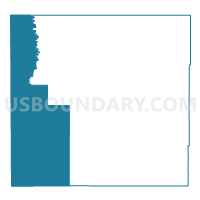
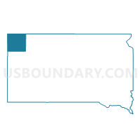
VTD-precinct -CampCrook, Harding County, South Dakota
About
Outline

Summary
| Unique Area Identifier | 667367 |
| Name | VTD-precinct -CampCrook |
| County | Harding County |
| State | South Dakota |
| Area (square miles) | 621.87 |
| Land Area (square miles) | 620.39 |
| Water Area (square miles) | 1.47 |
| % of Land Area | 99.76 |
| % of Water Area | 0.24 |
| Latitude of the Internal Point | 45.48207810 |
| Longtitude of the Internal Point | -103.87754230 |
Maps

Graphs
Select a template below for downloading or customizing gragh for VTD-precinct -CampCrook, Harding County, South Dakota


Neighbors
Neighoring Voting District (by Name) Neighboring Voting District on the Map
- Bowman 39-03 Voting District, Bowman County, ND
- Precinct 1, Carter County, MT
- Precinct 14, Carter County, MT
- Precinct 8, Fallon County, MT
- VTD - precinct 16 Minnesela, Butte County, SD
- VTD - precinct 6 Castle Rock, Butte County, SD
- VTD-precinct Hilton, Harding County, SD
- VTD-precinct Ladner, Harding County, SD
- VTD-precinct Poplar Grove, Harding County, SD
Top 10 Neighboring County Subdivision (by Population) Neighboring County Subdivision on the Map
- West Butte UT, Butte County, SD (2,686)
- Baker CCD, Fallon County, MT (2,522)
- Ekalaka CCD, Carter County, MT (758)
- North Harding UT, Harding County, SD (548)
- Alzada-Boyes CCD, Carter County, MT (402)
- South Harding UT, Harding County, SD (314)
- West Bowman UT, Bowman County, ND (104)
- Camp Crook town, Harding County, SD (63)
Top 10 Neighboring Place (by Population) Neighboring Place on the Map
Top 10 Neighboring Elementary School District (by Population) Neighboring Elementary School District on the Map
Top 10 Neighboring Secondary School District (by Population) Neighboring Secondary School District on the Map
Top 10 Neighboring Unified School District (by Population) Neighboring Unified School District on the Map
- Belle Fourche School District 09-1, SD (7,962)
- Bowman County Public School District 1, ND (2,714)
- Baker K-12 Schools, MT (2,470)
- Harding County School District 31-1, SD (1,255)
Top 10 Neighboring State Legislative District Lower Chamber (by Population) Neighboring State Legislative District Lower Chamber on the Map
- State House District 39, ND (13,645)
- State House District 28B, SD (9,885)
- State House District 39, MT (8,893)
Top 10 Neighboring State Legislative District Upper Chamber (by Population) Neighboring State Legislative District Upper Chamber on the Map
- State Senate District 28, SD (19,903)
- State Senate District 20, MT (18,169)
- State Senate District 39, ND (13,645)
Top 10 Neighboring 111th Congressional District (by Population) Neighboring 111th Congressional District on the Map
- Congressional District (at Large), MT (989,415)
- Congressional District (at Large), SD (814,180)
- Congressional District (at Large), ND (672,591)
Top 10 Neighboring Census Tract (by Population) Neighboring Census Tract on the Map
- Census Tract 9676, Butte County, SD (2,972)
- Census Tract 1, Fallon County, MT (2,890)
- Census Tract 9653, Bowman County, ND (1,296)
- Census Tract 9687, Harding County, SD (1,255)
- Census Tract 3, Carter County, MT (1,160)
Top 10 Neighboring 5-Digit ZIP Code Tabulation Area (by Population) Neighboring 5-Digit ZIP Code Tabulation Area on the Map
- 57717, SD (8,007)
- 59313, MT (2,498)
- 59324, MT (821)
- 57720, SD (651)
- 58651, ND (475)
- 57724, SD (210)
- 59311, MT (159)
- 57776, SD (15)